Search This Blog

Showing posts with label walks. Show all posts

Sunday, 2 November 2014

The forgotten world of the Lyme Regis landslip

                                                                                                                   Illustration by David Juniper
The open coast of Lyme Bay, with its fields, cliffs, and beaches, is like a sunny balcony facing south. This ends at Lyme town, tight up against the western end of Dorset. Beyond here, the way is blocked by a wilderness, which has been called the only jungle in England

It is almost impassable, though not quite: there is a precarious path. With a little imagination you could turn this into a fairy story: a seaside kingdom, ending at a mysterious forest, through which an adventurer penetrates to discover another land!

The Undercliff is a five-mile section of coast where the clifftops stand well inland, because the ground has broken away and falls in a long jumble to the sea. Because the layers of rock slope seaward and are lubricated by water, they keep slipping down over each other, rather like a tilted pack of cards.
The greatest slip happened on Christmas Day in 1839. Twenty acres of farmland split away, moving 300 feet out and down, and off the shore a reef was pushed up. The details were well studied by William Conybeare, a great geologist who happened to be vicar of Axminster. The reef disappeared, but the detached block, known as Goat Island, still had a sown wheat field on top, which next August was reaped by girls dressed as nymphs; and parties of visitors came to view the scene and take tea at Landslip Cottage. You can still see Goat Island and the Great Chasm behind it, though now obscured by trees.

In earlier times a small population was scattered through the Undercliff. There were grazing sheep and rabbits, charcoal-burners, several cottages. Over the past century it has been one of the few parts of England to become more wild instead of less. Perhaps it is haunted by its departed folk, and by the French Lieutenant’s Woman (Sarah Woodruff) who used to go walking in it, and the German prisoner of war said to have hidden out here, and whoever left the six-months-abandoned tent found by two children in 2003?


Under the forest canopy of oaks and ashes there is dense vegetation, ivy, wild garlic, horsetails, duckweed, badgers, foxes, adders, butterflies; 400 species of wildflowers have been recorded; various searches found 254 fresh-water invertebrates, 150 kinds of fly and wasp in five days, 89 kinds of lichen in one day.

At the Lyme end there are several ways in. From Monmouth Beach a path climbs beside a stream. From the Holmbush car park, a walk marked by pines joins the first path in a field, and they emerge onto a grassy hillside with a seat and a view down over the Cobb. From Ware Lane there is another footpath, also a gravel road. Last and most spectacular, from the upper end of Ware Lane a path goes past Ware Farm to the top of a fantastic spire called Chimney Rock. Here you are among the treetops, and you descend winding steps into their shadows.

All these ways unite in what is at first a wide earthen avenue into the forest. It doesn’t stay this easy! It becomes a thread along the tops of knife-edge ridges, between crevasses some of which are filled with bright green pools; later, it clambers with steep steps in and out of gullies. Much of the time you cannot see the sea, though it is not far below. About two miles in, you pass an old pumping station, once used to supply Lyme with spring-water.

Half way along, if you’ have had enough, you can take an easy path up a ravine, to emerge among the buildings of the Rousdon estate. This started as a mansion built by the rich grocer Sir Henry Peek; later it was Allhallows School. Peek had water pumped up from the Undercliff to fill his ornamental lakes; and when an Italian ship sank in the bay he had its cargo of marble statuary hauled up by donkeys to decorate his house.

But if you press on, after another mile and a half you are passing along the seaward flank of Goat Island. The path is sometimes runs close to the sea, sometimes steeply higher, and eventually it curves to brings you out of the Undercliff, to the top of a bright green valley, now filled by a golf course, down which there is a marvellous view across the estuary of the Axe to the tall white cliff between Seaton and Beer. From Seaton you could catch a bus back to Lyme.
By Guy Ottewell
Since Guy wrote this piece the dire weather of early 2014 means this fascinating classic walk is closed due to slippage. Hopefully it will reopen soon. I.D.


Friday, 24 October 2014

Dorset walks - A stroll between Poundbury and Maiden Castle

Here is a small exercise in compare and contrast. 
A footpath conveniently meanders across the fields joining the brand spanking new settlement of Poundbury to the the rather more ancient one of Maiden Castle.


Its a good little hike especially if you have visitors that need entertaining. It's just a paltry forty minutes each way with loads to interest at both ends, and a plethora of cafes at Poundbury.


Wednesday, 8 October 2014

Hills and Views - Maiden Castle


Maiden Castle, the largest Iron Age hill fort in Europe, occupies a low hill just a mile or so from the town of Dorchester, yet  it still manages to retain an atmosphere of airy isolation. The still-lofty defensive banks and ditches rise up like frozen waves and are a charmed place to lie back and listen to the atmospheric cry of the invisible skylark.

To really appreciate the earthwork requires wings, as only then can you appreciate the sophisticated layout of this ancient structure.
Here, 2000 years ago, the Roman army, led by Vespasian faced the local lot, the Durnovaria, in a battle that was probably a forgone conclusion; British slingshots would have been no match for Rome's state-of-the-art ballistas.
The story of their last stand was painted in chilling detail when archaeologist Mortimer Wheeler conducted an extensive dig here some seventy years ago. A mass grave of the defenders was uncovered, the skeletons clearly exhibiting battle wounds; while huge reserves of slingstones brought from nearby Chesil Bank lay unused .
Today life here is much more peaceful, the occupation force is mainly sheep, lambs and dog walkers; the hill's occupants having  long ago forsaken their ancestral home for the bright lights of Dorchester town.


Tuesday, 30 September 2014

Hills and views- The Hardy Monument

The monument in the Autumn mists
High on a hill near Dorchester, and visible for many miles around, stands a monument to a man chiefly remembered for kissing a sailor.
The Hardy monument, a rather squat ugly edifice, was erected in 1844 to the memory of the other Hardy, Trafalgar veteran Admiral Thomas Masterman Hardy.
So kissable....
Hardy, born at Long Bredy in1769 lived close by at Portesham. 
He was captain of the Victory at Trafalgar when his dying friend, Nelson, uttered those three fateful words, 'Kiss me Hardy,' so consigning the poor bloke to be the butt of schoolboy jokes for eternity.


There is another more prurient version of these events, by the way, with Nelson's dying words being interpreted as 'Kismet, Hardy'... meaning...'Fate, Hardy.'
Away from the smoke of battle the views across Dorset are breathtaking. Footpaths radiate to all points of the compass as do bridleways; so bring you dog or mountain bike or even a mountain biking dog.

Thursday, 11 September 2014

Hills and Views - Durlston Country Park


 Durlston Country Park sits high on the Purbecks above Swanage. It possesses probably the best views for the least amount of effort in Dorset and...better sit down at this point...it's free.


Durleston Castle - Knights Templar...?
The Durlston estate originally belonged to George Burt, local boy made good, who made his money helping his uncle John Mowlem in London.  If the surname sounds familiar it is because uncle founded  Mowlems, one of the biggest Victorian civil contractors which survives to this day.
George had dreams of putting Swanage on the map and of his schemes was to create an upmarket housing development at Durleston.
The centre piece Durlston Castle was built in a typical Victorian mish-mash of styles. Alas, the castle was the only part of the plan ever to be realised. 
...or Italian Rennaisance?
Burt also arrived in Swanage with a whole bootful of large architectural antiques picked up from Mowlem developments from around the Victorian capital. These he  sprinkled around Swanage and explain the appearance of typical London cast iron bollards that are dotted incongruously around the castle grounds.


Durleston has recently been the subject of a brilliant piece of renovation with the castle now restored to its full glory, serving as an excellent interpretation centre and cafe.
The view from the cafe terrace is stunning, on a sunny day you really could imagine yourself sipping your cappuccino in Amalfi. 


Below the castle stands an iconic giant stone globe also installed by Burt and subject of a million happy holiday snaps over the last century.


The cliff path winds on past the quaintly titled Tilly Whim caves, in reality old quarry workings. These were once open to the public but are now unfortunately deemed unsafe. Beyond the view encompasses the whole of the Purbecks, while at your feet soft, springy turf beckons you to stretch out and simply...be.
Durleston lighthouse

Saturday, 30 August 2014

Dorset Walks - Portland

Portland has always been different. Its people. Its landscape. Its traditions.
Joined to the mainland by the merest sliver of shingle its only communication with mainland Dorset until 1839 was by ferry. In bad weather it could be cut off for days.
The best way to experience its otherness is to pull on a pair of boots and walk...the route is clear and simple and can easily be shortened by cutting across the island.
Distance around 8 miles


Thursday, 31 July 2014

Dorset Walks-Milton Abbas to Bulbarrow


This walk starts at Milton Abbas, a picture postcard village created in 1780 on the whim of the Lord of the Manor who deciding that the town of Middleton rather got on the way of his view, promptly demolished it, moving the population over the hill to the brand, spanking new village of Milton Abbas.

The route takes you past Milton Abbey and school and then passes one of the most idyllically situated school playing fields in England.

A long climb brings you to the brow of Bulbarrow Hill where you are rewarded with far-reaching views inland over the Blackmore Vale.

8.5 miles 4hrs approx.
Explorer 117 (Cerne Abbas & Bere Regis)

Saturday, 21 June 2014

Dorset walks 4- Litton Cheney, Little Bredy and the Valley of the Stones


These peaceful villages snuggle into the softly folding chalk escarpments of the Bride valley forming a part of a hidden Dorset overlooked by the crowds as they rush east and west along the A35.


The route climbs to the ridge high above the valley giving level walking and wonderful views; while a slight detour takes you to the Valley of Stones nature reserve. which is considered to be one of the finest examples 
 of a Sarsen stone boulder train in Great Britain (beat that Devon!). Conditions at end of the last ice age caused sandstone on top of nearby chalk hilltops to fragment and slump downhill. There is evidence that the site was used as an ancient 'quarry' with stones being taken from the area for use at other local megalithic sites such as the stone circle you'll pass.
Distance: 9 miles 3.5 hrs


hrs

Thursday, 22 May 2014

Dorset's Invisible monument

FOR YOUR DAILY DOSE OF DORSET ENTER YOUR EMAIL IN THE BOX ON THE RIGHT!


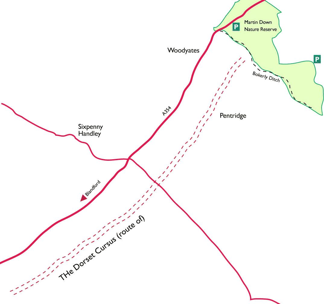
3,300 years ago, the Neolithic inhabitants of Wiltshire began building Stonehenge for the English tourist board. Not to be outdone the men of North Dorset set about building their own tourist attraction, one of titanic proportions known as  The Dorset Cursus.
It took the form of parallel chalk banks five feet high, six feet wide and spaced 300 feet apart flanked by deep ditches that snaked across the rolling downland of Cranborne Chase for a distance of six and a quarter miles. It has been estimated that it took around half a million man hours to construct.

Route of the Cursus seen from Martin Down
...So why aren't coach loads of sheep queuing up to get an eyeful? The reason is that it is nowhere to be seen. Blame it on dodgy building materials...unfortunately its earth and chalk construction proved less durable than stone, so that while Stonehenge still wows the public most of the Cursus has long since disappeared beneath the plough. Much of what is known about it is as a result of aerial photography and geophysical surveys.
The results of these investigations show that its course originally meandered across the gently rolling countryside between Bottlebush Down and Martin Down.


From the lofty viewpoint of Martin Down Nature Reserve (see walk below) you look down on the course of the Cursus. From here it takes just a little imagination to conjure those gleaming banks of white chalk stretching to the far horizon and to realise what an amazing monument it must once have been.

As to why the Cursus was constructed... no one really has any idea though theories abound, of course. Some say that it was a processional way or  even a Neolithic Aintree…hence the name 'cursus'. What is definite, though, was that the second bank seems to have been built some time after the first and meandered rather drunkenly across the countryside seemingly using the first bank as a guide. It also incorporates two long barrows built into each end.


A walk in Cursus country
Martin Down and along Brokerly Ditch (7 miles approx.)


This exhilarating walk takes you across Martin Down Nature Reserve and along Brokerley Ditch, a high bank and ditch dating from the bronze age and probably built to mark territorial boundaries. The Earthwork was enlarged after the Romans left, possibly as a defensive barrier against the invading Saxons and the structure still remains impressive to this day.

The far-reaching views from the top of the down  mark the beginning of the Cursus 

Saturday, 8 February 2014

Off the beaten track 1- The Cannington Viaduct SY338916

Ancient Rome? No... Railway Modern..
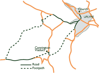
The Cannington Viaduct strides across this hidden valley with all the  self confidence of Empire; British though, rather than Roman, its monumental arches creating a breathtaking contrast with the soft green valley that surrounds it. 
You really don't have to be an enthusiast to admire this spectacular piece of railway architecture which was constructed in 1902 simply to carry the now-defunct Lyme Regis branch line. 
It was ground-breaking too, as it was one of the first structures to be cast entirely from concrete. Time passed, and like the Roman viaducts before it, so did its raison d'ĂȘtre when the last train rattled over it in 1968. Local folklore tells that it was supposedly sold to a bungee jumping company for 1p, though I've never known it used for that purpose. It is also sadly, a missed opportunity. The path of the old line that ran across it would have made a superb level cycleway between  Axminster and Lyme Regis. Sadly, encroaching gardens have put paid to that.
The best time to see it is early in the morning or in the evening when the golden light make it glow.
Much the nicest way to get there is the short 3.75ml walk detailed below.

Sunday, 2 February 2014

Hills and views 2- Lamberts Castle


A break in the weather and an early start saw us blowing the cobwebs away on Lamberts Castle. 
It is an Iron Age fort, as are most of Dorset's high points and until quite recent times, the site of a yearly fair. It is a favourite with dog walkers, horse riders, kite flyers and of course, us. 

The hill divides into two completely different environments. On one side paths run through a woodland of fantastically gnarled trees whose cover of moss makes them glow a vibrant green in the morning sunlight. A great place for chasing hobbits into hollow trunks, white rabbits down holes and for kids to have proper, rather than digital fun.

The other side is wide-open hillside with birdseye views that encompass most of Dorset. There are even seats from which to enjoy them. A perfect place for feeding your sandwiches to the passing mutts.